
Land Surveying and Consulting services in Whitefish, Flathead County and Lake County
Call (406) 201-9402
We are happy to provide a free initial consultation to discuss your project and get you moving in the right direction. WILD Surveying has over 20 years of experience providing friendly, responsive and expert Land Surveying and Consulting services. We have assisted attorneys, private land owners, consulting engineers, architects and developers with their geospatial and legal survey requirements. We approach every project with a responsive, professional and innovative mindset to consistently provide our clients with expert consulting and geospatial services.
What is an Exemption Survey?
There are two primary ways to divide property in Montana, through subdivision review or through an exemption survey. Requirements for subdivision review vary from County to County but typically involve lengthy review times and permitting processes prior to preliminary or final plat. Exemption surveys still require that a Certificate of Survey be prepared by a Professional Land Surveyor but are exempt from most of the longer requirements and permitting that traditional subdivision review involve. Please contact us at (406) 201-9402 for a free consultation to see if a qualifying exemption may be available: immediate family transfer, boundary line relocation, utility site survey, court order division, amended plat, lot aggregation or agricultural exemption.
Land Surveying
Project Surveying & Consulting
Engineering Surveying
Certificate of Survey (COS)
Utility easements and Right-of-Way retracement and creation
Conservation easements
Lot line staking
Find pins
Foundation layout and subdivision site services
Permitting
Certificate of Subdivision Approval (COSA)
Lakeshore Construction Permitting
Zoning Compliance Permits
Conditional Use Permits
FEMA Elevation Certificates and LOMAs
RV & Cabin Site Developments
Subdivision Exemptions
Immediate Family Transfer
Boundary Line Adjustment (BLA or BLR)
Lot Aggregation
Utility Site Survey
Mortgage Survey
Court Order Survey
Condominium Conversion
Townhouse Development
Site Surveys & Mapping
Part 107 UAV Drone Mapping
Orthometric and 360 Site Assets
Topographic Mapping
360 Aerial Inspections
LiDAR acquisition
Land Surveying Services in Whitefish, Montana
WILD Surveying provides professional land surveying services in Whitefish and throughout Flathead County.
We assist property owners, developers, architects, and builders with boundary retracements, exemption surveys, lot consolidations, and zoning conformance permitting support within the City of Whitefish.
Our experience with local zoning, challenging terrain, and permit review processes allows us to efficiently guide projects from initial research through finalizing a site plan to construction layout.
Boundary & Retracement Surveys
Subdivision Exemption Surveys
Site Plans for Zoning Conformance
Setback staking
Elevation Certificates
Permitting & City Review Support
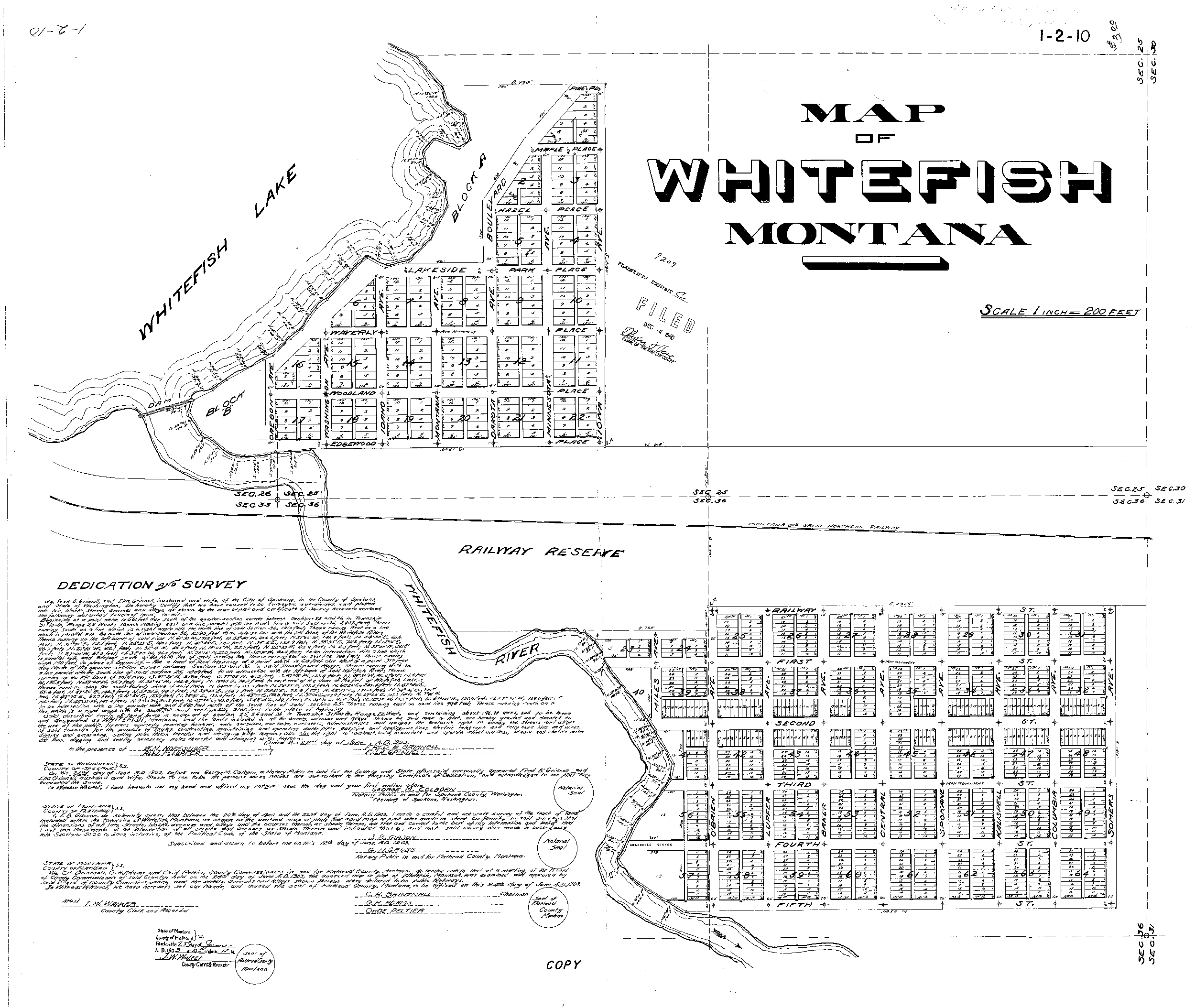
1903 Original Subdivision Plat of Whitefish
Recent WILD Projects
Whitefish, Montana | Site Survey for Zoning Conformance
Project Description: Big Mountain Hardscapes hired WILD Surveying to find property corners and define property boundaries for Zoning Conformance for a residential hardscape project within City of Whitefish limits.
Lakeside, Montana | Boundary Line Adjustment for Venue Parking Expansion
Project Description: WILD Surveying provided the technical support for a Boundary Line Adjustment to accommodate a parking lot expansion for cabin rental and wedding venue in Lakeside Montana. WILD Surveying worked with both landowners and Flathead County to complete the project.
Kalispell, Montana | Floodplain Permitting for Investment Property
Project Description: WILD Surveying provided the technical support for a Flathead County Floodplain Permit application. Applicant was required to demonstrate that the structure was located above the Base Flood Elevation (BFE) as required by floodplain regulations. Utilizing drone and GPS technology WILD Surveying was able to provide an elevation survey to ensure project continued and complied with permitting requirements.
Missoula, Montana | Existing Conditions Plan for AEC Design & Zoning Compliance
Project Description: WILD Surveying provided the boundary surveying and topographic mapping to complete the base Existing Conditions Plan for the project architect, engineer and construction team. This property is located in an historic subdivision in the City of Missoula where accurate surveying is critical to project compliance with zoning setback requirements.
Evergreen Water and Sewer District - Municipal Tank Site
Project Description: WILD Surveying provided the surveying for upgrade of municipal water facilities which included: wetland mapping, aerial imagery, existing conditions topographic survey for engineering design of upper tank site and lower well field and adjacent wetland. A boundary line adjustment survey with the abutter was performed as part of this upgrade.

Swan Marina - Marina Redesign & Lakeshore Permitting
Project Description: WILD Surveying worked with client on surveying, design and permitting of 20+ slip marina on the south end of Swan Lake in Lake County. Surveying services included, riparian boundary, retracement, existing conditions plan, bathymetric survey, marina design, project consulting and permitting for site development.